Case Studies

11.15.26
Urban Hawk Transforms Everyday Fleet Miles Into Roadway Intelligence
Cities must maintain aging roads with limited budgets. Traditional pavement surveys and manual asset inventories are costly, time-consuming and quickly become outdated.
Mitsubishi Electric Automotive America’s Urban Hawk platform offers a better approach. It turns municipal vehicles into mobile data collectors, using dashboard cameras, computer vision and geospatial analytics to identify pavement conditions and roadside assets as vehicles follow their normal routes.
We tested this approach at Curiosity Lab in Peachtree Corners, Georgia, collaborating with the Lab and the city to evaluate Urban Hawk in real-world conditions.
Nine dashboard cameras were installed on Curiosity Lab and city maintenance vehicles. As they traveled their regular routes, the system collected imagery without disrupting operations or requiring dedicated survey runs.
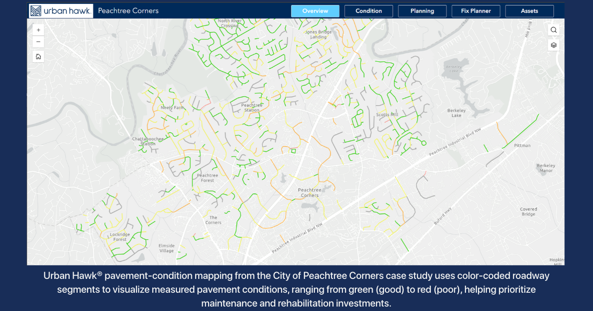
The deployment covered 111.93 roadway miles and processed 119,748 image frames. Urban Hawk assessed 1,031 road segments, recorded 6,568 pavement degradation observations and detected, classified and geolocated 8,123 roadside assets.
Those assets included 1,719 light poles, 1,236 utility poles, 1,171 garbage bins and 1,059 road covers, along with traffic control devices, accessibility pads, guardrails, storm drains and signs.
Cities can use the imagery to assess pavement and inventory roadside assets, maximizing the value of every mile driven.
We made the results accessible through a geographic information system (GIS) web application. City staff could view mapped conditions, examine supporting images and investigate individual detections without sorting through static reports or disconnected systems.
More importantly, the data transitioned from technology testing into daily operations. Urban Hawk uses proprietary machine-learning technology to evaluate pavement conditions, generate segment-level condition ratings, and create comprehensive asset inventories. Its hardware-agnostic design lets municipalities use existing fleets instead of investing in specialized collection vehicles. Retained imagery also supports future analysis without requiring another drive. Peachtree Corners staff used pavement assessments to prioritize maintenance, research check citizen complaints against current imagery and direct remaining year-end budget dollars toward high-impact repairs.
The deployment demonstrated how we can turn routine municipal operations into a continuous source of infrastructure intelligence. Rather than relying solely on periodic surveys, cities can use up-to-date data to identify problems, investigate complaints and make better-informed maintenance decisions.
For Peachtree Corners, that means a clearer view of roadway conditions and the assets crews manage. For Urban Hawk, it validates the technology in an active municipal environment.
“Public agencies face a growing challenge with managing infrastructure costs while resources are static or declining. The Urban Hawk platform started out as a partnership with our Curiosity Lab because it fit our goal of operating outside the mold of standard transportation means and methods,” said Greg Ramsey, PE, Director of Public Works & Engineering, City of Peachtree Corners. “The deliverable provided our team with informed insights into our assets without requiring separate resource allocations. Doing more with less is impossible, but our team was able to use Urban Hawk to do more with the same.”
Cities face growing demands to maintain safer roads while stretching limited budgets. Urban Hawk offers a practical solution to meet those demands: equip existing vehicles, collect imagery during routine operations, analyze the data and put the results to work.
The Road, Understood. In Peachtree Corners, we demonstrated how better understanding can start with the miles city vehicles drive every day.


Subscribe for the Latest
Subscribe for the Latest